Search Our Content Library
- Accredited Learning
- Adobe
- AI in AECO+D&M
- Arch-Intelligence
- Autodesk
- Autodesk Construction Cloud
- AVAIL
- Bentley
- Bluebeam
- Business & Management Skills
- Camtasia
- Enscape
- Esri
- EVOLVE MEP
- Global BIM Standards
- Green Badger
- Guardian
- Health & Safety (HSI)
- Ideate Software
- Lumion
- Manufacturing Design
- MarkedUp
- McNeel
- Microsoft
- Newforma
- Newforma Konekt
- OneClick LCA
- Panzura
- Pinnacle Series
- Procore
- Project Management
- Revizto
- SketchUp
- SmartDraft
- Solibri
- SOLIDWORKS
- Tekla
- Trimble
- Twinmotion
- US Army Corps of Engineers
- V-Ray
- Course Library
- /
- Civil 3D 2027
- /
- Exchanging Data between Civil 3D & ArcGIS Online
Learning Path Courses:
-
Autodesk Connector for ArcGIS
Autodesk Connector for ArcGIS Course Introduction (Course Duration: 33 minutes) Course Description In this course, you will learn how to use the Autodesk Connector for ArcGIS to exchange data between ArcGIS online and Civil 3D. Using the Autodesk Connector for ArcGIS you can link your Civil 3D drawings to data sources in ArcGIS online, and push updates in both directions. You can add data from ArcGIS online, edit and append an ArcGIS data source, and publish Civil 3D objects to a new data source in ArcGIS online. Course Objectives The material presented in this course teach you how to: · Import data from ArcGIS online · Edit and append ArcGIS data sources in Civil 3D · How to Save Back and Refresh ArcGIS data sources · How to Publish ArcGIS data sources · Manage ArcGIS datasets Course Prerequisites To participate in this training course, you should have the following: · None Tips: · Turn off your phone, close your email, text and social media apps. · Plug headphones or ear buds to your computer. · Go Full Screen when watching videos.
Like what you see? We’d love to give you a guided tour of the best Pinnacle has to offer.
Book Your DemoTrusted By Leaders








Before You Go
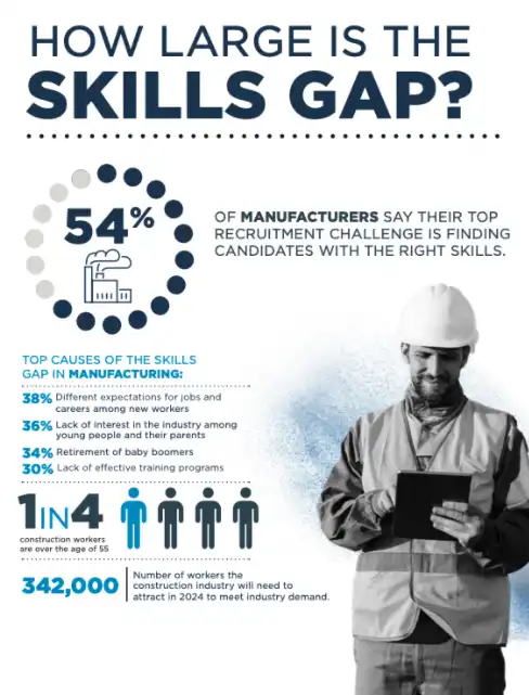
Understanding the Manufacturing & Construction Skills Gap
We went deep into the latest market research and created a resource to give you fresh insight into your recruitment challenges.