Getting Started covers the OpenUtilities Map interface, the Command Manager, and the Map Manager, then introduces property based mapping, the rules-driven approach OpenUtilities uses to symbolize and place features based on their data.
Search Our Content Library
- Accredited Learning
- Adobe
- AI in AECO+D&M
- Arch-Intelligence
- Autodesk
- Autodesk Construction Cloud
- AVAIL
- Bentley
- Bluebeam
- Business & Management Skills
- Camtasia
- Enscape
- Esri
- EVOLVE MEP
- Global BIM Standards
- Green Badger
- Guardian
- Health & Safety (HSI)
- Ideate Software
- Lumion
- Manufacturing Design
- MarkedUp
- McNeel
- Microsoft
- Newforma
- Newforma Konekt
- OneClick LCA
- Panzura
- Pinnacle Series
- Procore
- Project Management
- Revizto
- SketchUp
- SmartDraft
- Solibri
- SOLIDWORKS
- Tekla
- Trimble
- Twinmotion
- US Army Corps of Engineers
- V-Ray
- Course Library
- /
- Bentley Learn OpenUtilities
- /
- OpenUtilities Map User Training
Learning Path Courses:
-
Getting Started
-
Interoperability
Interoperability covers exchanging data with other systems: attaching references, managing raster images, importing and exporting data, connecting to spatial databases, and consuming web services.
-
Feature Authoring
Feature Authoring covers placing and editing utility features, reviewing and managing feature data in the Data Browser, and managing conduit and cable relationships with Conduit Management.
-
Introduction
Introduction provides an overview of OpenUtilities Map and its role as a GIS-based platform for designing and managing electric, gas, water, and other utility networks.
-
Printing
Printing covers using print templates to produce consistent, repeatable map output.
-
Analysis
Analysis covers cable pulling analysis, used to plan and validate how cables are routed and pulled through conduit.
-
Network Tracing
Network Tracing covers tracing connectivity through a utility network to analyze upstream and downstream relationships between features.
Like what you see? We’d love to give you a guided tour of the best Pinnacle has to offer.
Book Your DemoTrusted By Leaders








Before You Go
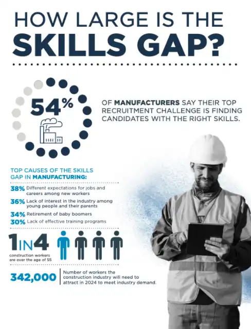
Understanding the Manufacturing & Construction Skills Gap
We went deep into the latest market research and created a resource to give you fresh insight into your recruitment challenges.