Search Our Content Library
- Accredited Learning
- Adobe
- AI in AECO+D&M
- Arch-Intelligence
- Autodesk
- Autodesk Construction Cloud
- AVAIL
- Bentley
- Bluebeam
- Business & Management Skills
- Camtasia
- Enscape
- Esri
- EVOLVE MEP
- Global BIM Standards
- Green Badger
- Guardian
- Health & Safety (HSI)
- Ideate Software
- Lumion
- Manufacturing Design
- MarkedUp
- McNeel
- Microsoft
- Newforma
- Newforma Konekt
- OneClick LCA
- Panzura
- Pinnacle Series
- Procore
- Project Management
- Revizto
- SketchUp
- SmartDraft
- Solibri
- SOLIDWORKS
- Tekla
- Trimble
- Twinmotion
- US Army Corps of Engineers
- V-Ray
- Course Library
- /
- AutoCAD Map 3D 2025
- /
- Working with Connected Maps Workflow
Workflow Processes:
-
Connect to Map Data
This process walks through connecting data, reviewing the graphics, and setting the styles. -
Edit Connected Source Features
This process outlines the tasks and steps that can be used to edit map features and save the edits back into their source drawings. -
Analyze Connected Data (Features)
Determine what information or combination of different types are needed for the analysis. The results from one analysis can be used or combined with others to get the final result. For example, how to find where roads should be closed for hazardous material removal from some buildings. A query can be done of a building feature layer, to find those that have the specific property related to the hazardous material. A buffer then could be built from those buildings, such as a required safe distance. Once completed, that buffered query can be used to overlay roads to determine where road closures need to be established. -
Export Data
This process outlines tasks and steps that can be used to export mapping data into other widely used products, including Autodesk AutoCAD and Autodesk AutoCAD Civil 3D.
Like what you see? We’d love to give you a guided tour of the best Pinnacle has to offer.
Book Your DemoTrusted By Leaders








Before You Go
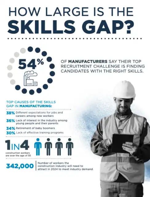
Understanding the Manufacturing & Construction Skills Gap
We went deep into the latest market research and created a resource to give you fresh insight into your recruitment challenges.